Diese Seite gibt es auch auf Deutsch.

Cette page existe aussi en français.

Esta página también está disponible en español.

Questa pagina è disponibile anche in italiano.

Deze pagina is ook beschikbaar in het Nederlands.

Ta strona jest dostępna także po polsku.

Pedalglobe · Bike routes & best time to go

From the evening loop to the trip around the world.

Set start and finish, and Pedalglobe builds the bike route: worldwide along cycle paths, long-distance cycle routes and quiet roads, calculated right on your device, even offline. Plus the climate for every day of your trip and what applies at every border. No account, no subscription.
Download on the App Store See the features

For iPhone and iPad with iOS and iPadOS 26.1 or later and for Macs with Apple silicon · Free download, Pedalglobe Pro as a one-time purchase · English, German, French, Spanish, Italian, Dutch and Polish

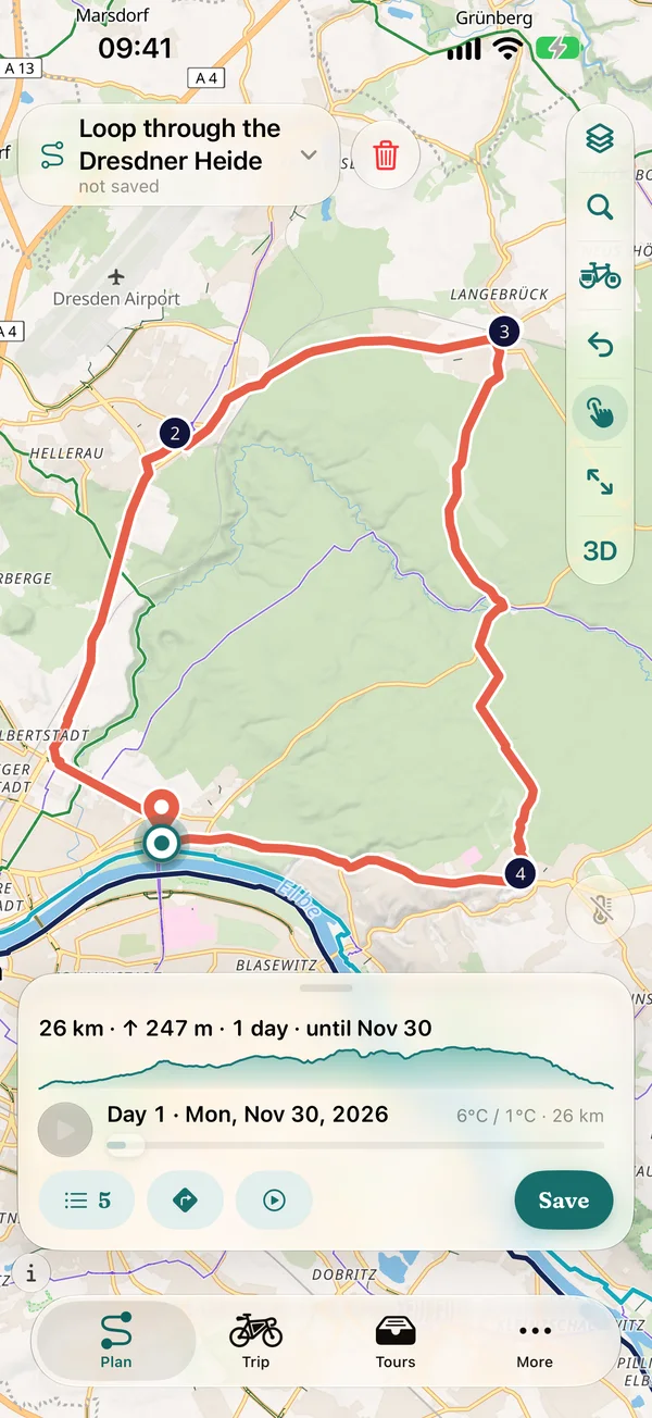
“Loop through the Dresdner Heide” in the planner: a loop from the Elbe via Hellerau and Langebrück and back to the Elbe, 26 km, 247 m of climbing, 1 day until Nov 30, the profile line and Day 1 on Mon, Nov 30, 2026 in the collapsed panel
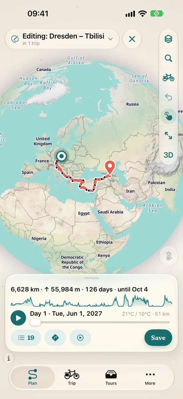
Route Dresden – Tbilisi in the planner on the globe, at the top “Editing: Dresden – Tbilisi” in 1 trip: the route across the Balkans and Turkey with 19 waypoints, in the collapsed panel 6,628 km, 55,984 m of climbing and 126 days until Oct 4

For every ride

  • Everyday

    The loop after work.

    From your front door, made for your bike, with climbs and surfaces. Save it, find it again under “Tours”, ride.

  • Adventure

    The trip that lasts for weeks.

    Daily stages, the climate for every day, passports and borders in view, maps and routing even offline.

Trip ideas to ride

All 10 trip ideas

Build the route, find the time, ride

Pedalglobe calculates your bike route worldwide on your device, splits it into daily stages and shows for every day how warm, wet or windy it is there on average. For a weekend tour as well as for trips that last weeks or months.
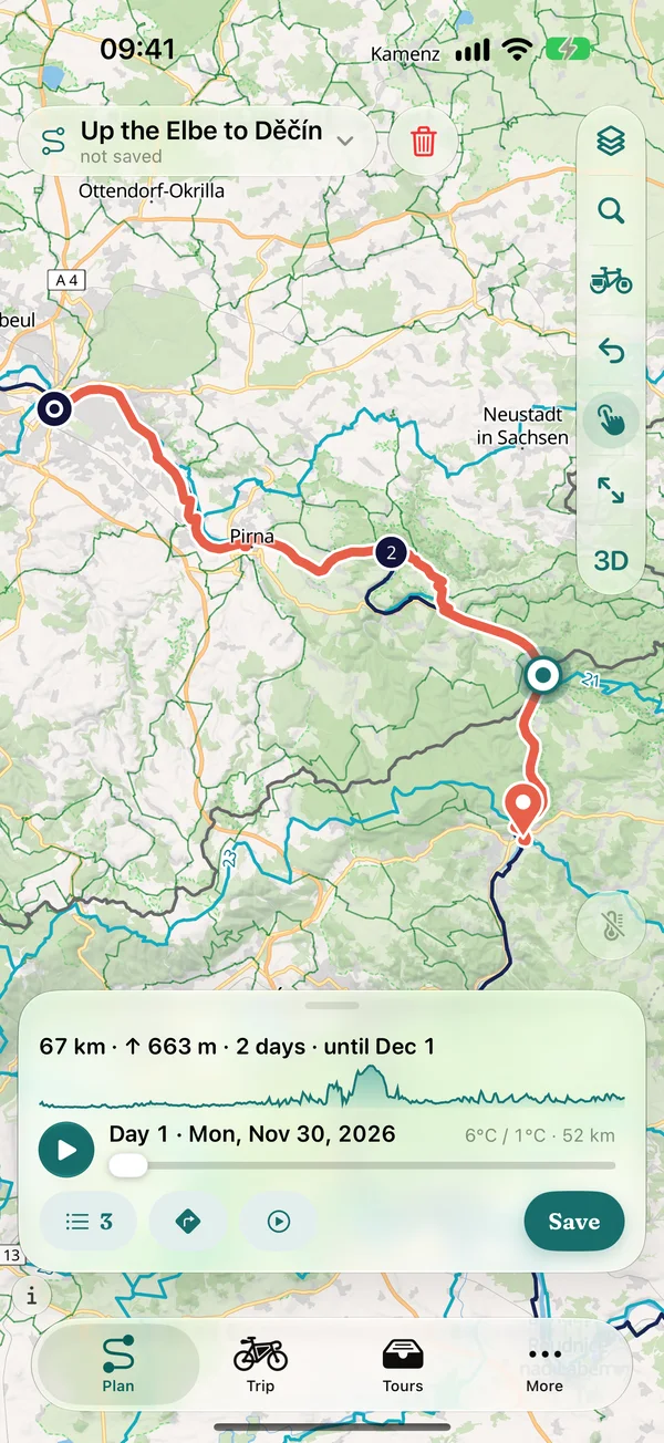
Route planner on iPhone: route “Up the Elbe to Děčín” from Dresden via Pirna, 67 km, 663 m of climbing, 2 days until Dec 1, in the panel the profile line, Day 1 on Mon, Nov 30, 2026 and the buttons for 3 waypoints, navigation, 3D flight and save
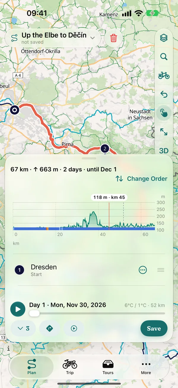
The same route with the expanded elevation profile: a tapped point at km 45 at 118 m, day boundary and the surface band below, at the top “Change Order”, below Dresden as the start

Build routes

Bike routing worldwide, calculated on your device

Set start, finish and waypoints on the globe or the map. Pedalglobe builds the route along cycle paths, long-distance cycle routes and quiet roads, with climbing and elevation profile. The calculation runs on your iPhone, iPad or Mac itself, nothing is sent to a server to calculate it.
  • Touring
  • Gravel
  • Road
  • Bikepacking
  • Mountain
  • E-bike
  • Six bike types with their own pace and preferences for ways and surfaces: the road bike stays on asphalt, the mountain bike takes any trail
  • Worldwide, also offline: download routing data per country or per section along the route, with the size shown first
  • Elevation profile while planning, also on iPhone: a profile line in the panel, expanded the whole profile with day boundaries. One tap shows elevation and kilometre, and the map jumps there
  • Surface band per section: asphalt, gravel and path as a coloured bar under the profile and at every waypoint, expandable by type of way, plus every climb with length and gradient
  • Import GPX: keep it exactly (1:1) or snap it to the paths, with both lines on the map to compare
  • Search places, regions, mountains and rivers (also offline), addresses with house numbers via Apple Maps, set and reorder points
  • Pace and rest days: Pedalglobe splits your trip into daily stages and shows when you will be where
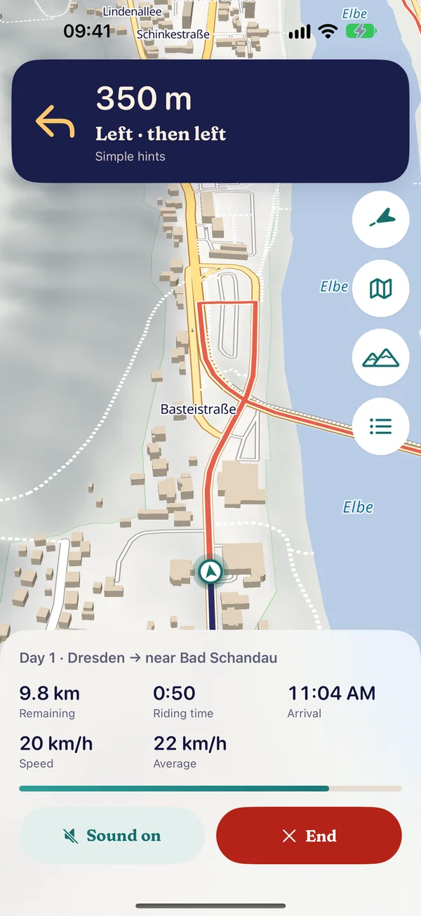
Navigation along the Elbe on Day 1 Dresden → near Bad Schandau: banner “350 m Left · then left”, map facing the direction of travel with buildings, below 9.8 km remaining, 0:50 riding time, arrival 11:04 AM, speed and average, buttons “Sound on” and “End”
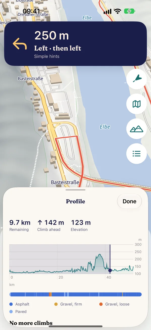
Navigation with “Profile” open: 9.7 km remaining, 142 m of climbing ahead, elevation 123 m, elevation profile with the current position, surface band and legend, below “No more climbs”

Navigation

Turn by turn to your destination

Pedalglobe guides you along your route with spoken directions, so your eyes stay on the road.
  • Turn-by-turn directions with voice guidance in eleven languages
  • Takes you day by day through your stages, after you arrive you carry on with the next day
  • Tilted map facing your direction of travel with relief and buildings, a calm camera without jumps, dark at night
  • “Overview” shows the whole remaining route and returns with one tap, “Profile” the elevation profile with surfaces and the next climbs, navigation keeps going meanwhile
  • Keeps running while your iPhone is locked, with the next turn on the lock screen
  • Picks up where you were after a crash
  • Records your ride: the ridden track on the trip map, plan vs. actual per day, GPX
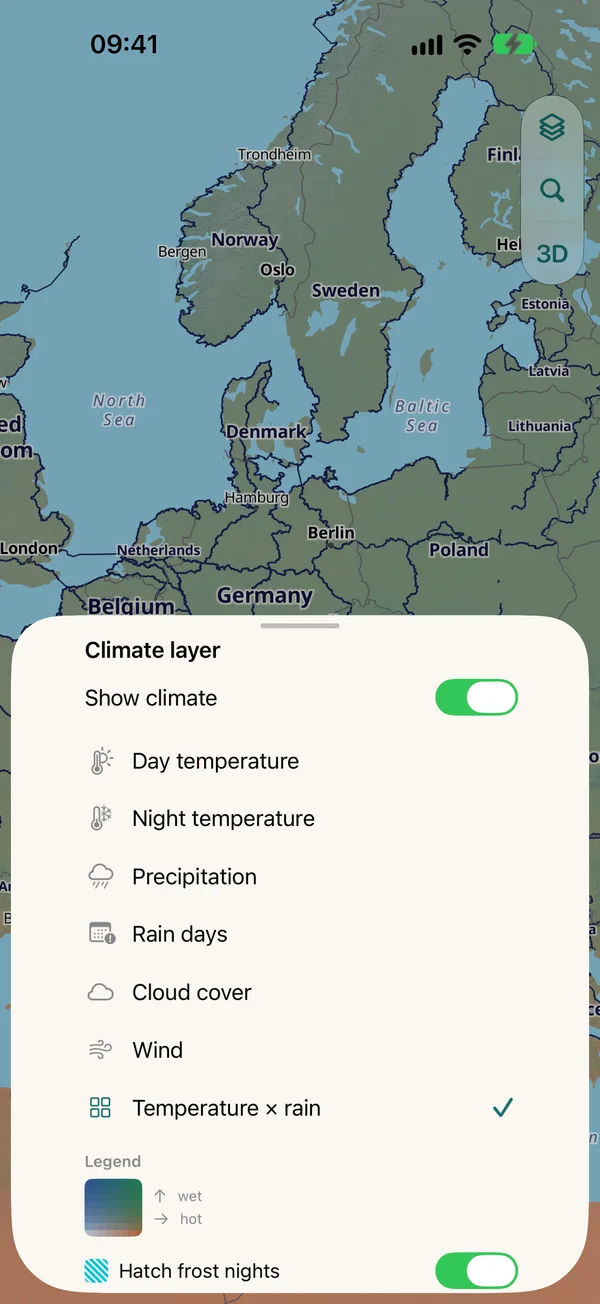
Climate layer menu: day and night temperature, precipitation, rain days, cloud cover, wind and temperature × rain with legend, plus switches to hatch frost nights and heavy rain

When to go?

Climate and the best departure window

  • Climate map on the globe with a timeline: temperature × rain, day and night temperature, precipitation, rain days, cloud cover and wind for every day of the year
  • Every day of your trip is rated against your own limits for cycling, camping at night and heat
  • Best departure window: for every departure week, Pedalglobe works out how many days would be pleasant

Climate values are long-term averages for 1995–2024 (cloud cover and wind 1981–2010), not a weather forecast.
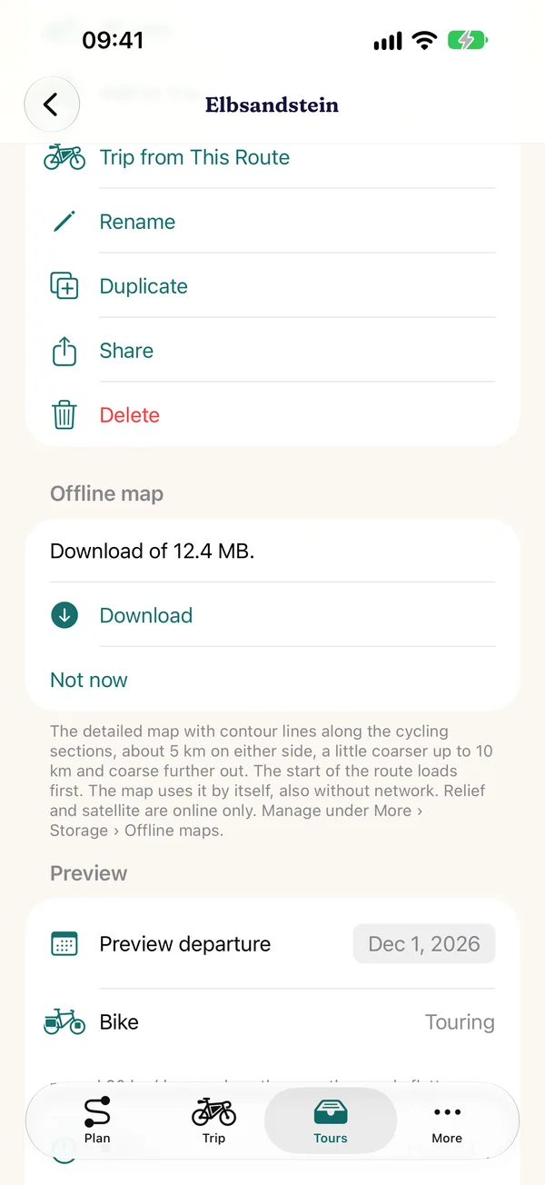
Saving the offline map of a route in the Elbe Sandstone Mountains: 12.4 MB download, with contour lines along the cycling sections

Offline

Offline maps for the road

  • Country packs: download a whole country with routing and an offline map, up to about 5 km beyond the border. You see the size first.
  • Or save just the map along your trip or route. Pedalglobe downloads it in trip order, so the start is ready first, with pause and resume. “For the road” downloads everything one after the other and carries on even days later.
  • The cycle network and contour lines come along for the same area, and a world overview map with terrain relief is built into the app
  • Offline you then have the map, cycle network, contour lines, routing, climate, place search, country information, routes and trips

Satellite, relief and the 3D view load over the internet.
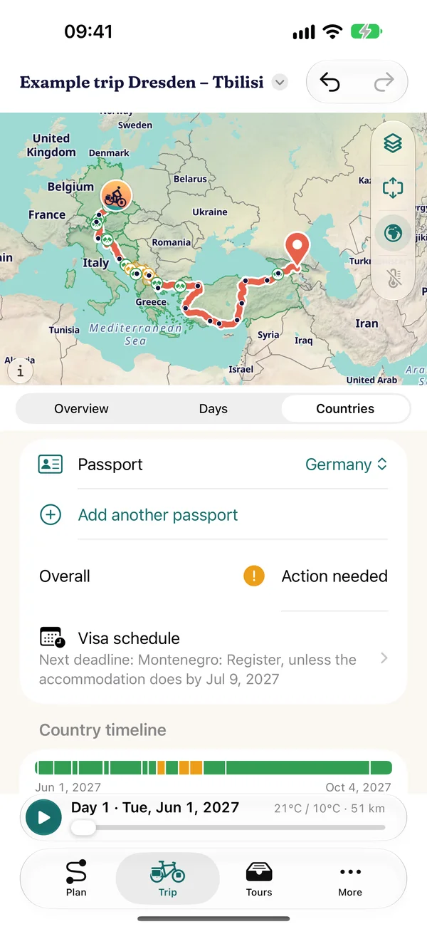
Countries of the example trip Dresden – Tbilisi with a German passport and the option to add more passports: overall assessment, visa schedule with the next deadline for Montenegro and the country timeline from 1 June to 4 October 2027

Countries and visas

What applies at the next border?

  • Entry rules and permitted length of stay for more than 180 destinations worldwide, about 600 rules checked against official sources
  • For EU, Swiss, Norwegian, UK, US and Canadian passports, partly also Australian and New Zealand passports
  • Several passports at once, for example with dual citizenship, with links to the foreign ministry of every passport you choose
  • For every country on the route: languages, currency, emergency numbers, plugs, time zone and links to official sources, for more than 200 countries and areas
  • Country timeline and visa schedule: planned against permitted days, deadlines as a calendar file

Every item shows its source and date. No guarantee – only the authorities of the destination country are binding.
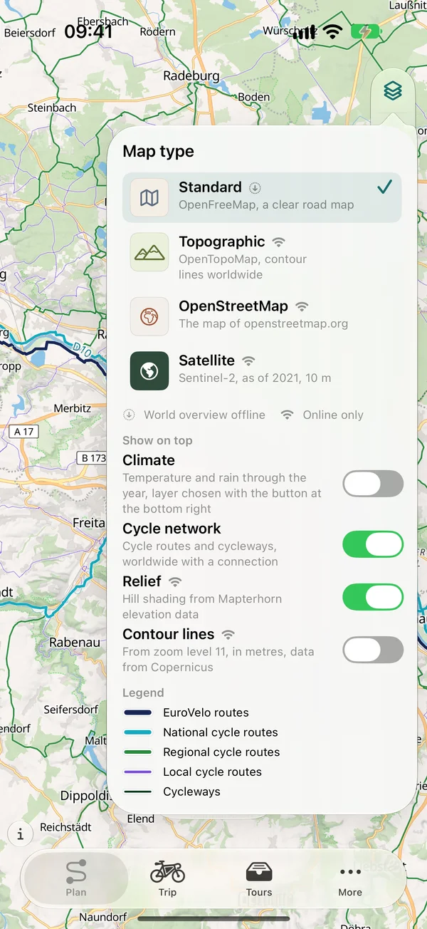
Map type menu: Standard, Topographic, OpenStreetMap and Satellite, with switches for Climate, Cycle network, Relief and Contour lines

Maps

Map types, relief and contour lines

  • Map types standard, topographic, OpenStreetMap and satellite
  • Cycle network overlay: cycle routes and paths worldwide, with numbers on long-distance routes
  • Worldwide relief that shows mountains and valleys in shaded relief
  • Worldwide contour lines, computed from the Copernicus elevation model, over every map type
  • Tilted map with relief and buildings in navigation

Globe and 3D

3D view and 3D flight

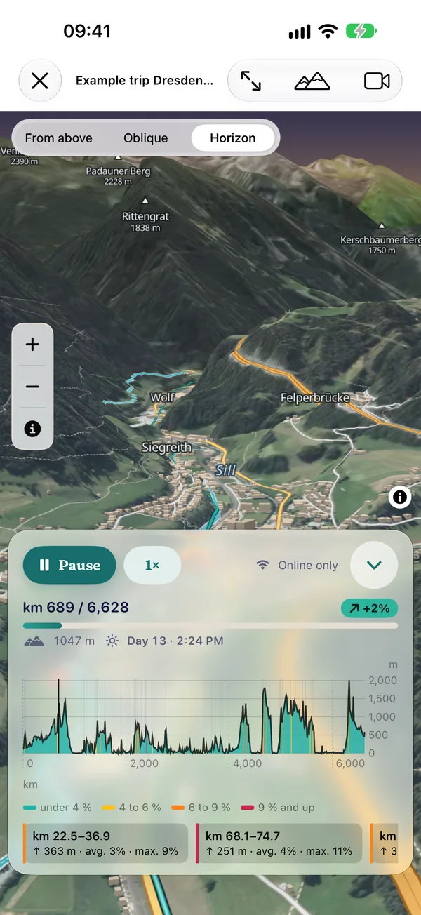
Plan on the globe or on the flat map. At launch the globe greets you in the light of the time of day. The 3D view shows your route over satellite imagery and terrain, and the 3D flight takes you along it, on the open 3D map with horizon or in “Apple 3D”, switchable during the flight.
  • 3D with roofs, your route shines through behind buildings
  • 3D flight free up to 1,500 km and on the example trip, with Pro over any distance
  • You can record the flight as a short video, free with a small watermark
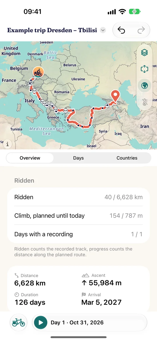
Overview of the example trip Dresden – Tbilisi: map with the route across the Balkans and Turkey, section “Ridden” with 40 of 6,628 km and one day with a recording, below 6,628 km, 55,984 m of climbing and 126 days
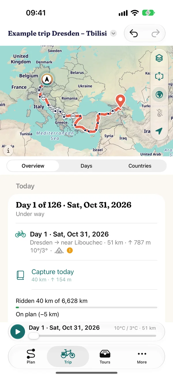
Trip › Today: day 1 of 126 on Sat, Oct 31, 2026, under way, stage Dresden → near Libouchec with 51 km and 787 m of climbing, below “Capture today”, ridden 40 of 6,628 km, on plan (−5 km)

Trips and on the road

One trip, many routes

  • Combine routes into a trip and connect them by train, bus, ferry or plane
  • All your routes and trips live together under “Tours”, to search, sort and keep planning
  • Travel mode “Today”: stage of the day, plan vs. actual from your recorded ride, visa countdown, “Replan from today”
  • Your rides in the logbook under “Tours”: save as a route, share as GPX, encrypted in your iCloud on all your devices
  • Through “Share”: GPX for the whole trip or per day, and a roadbook as PDF
  • Share with people close to you: follow along or ride along on a trip through iCloud, the logbook with photos, an image for your status and story
  • Invite people under “Along for the ride”, separate from sharing. Whether others see your position is up to you with “Share position”

iPhone, iPad, Mac and iCloud

On all your devices

  • Compact on iPhone, with sidebar and inspector on iPad
  • Sync between your devices through your private iCloud (can be turned off). Without iCloud you back up everything to a file.
  • On the Mac too: Pedalglobe runs as an iPad app on Macs with Apple silicon, and your trips come along through iCloud
  • A short tour to start, from the evening loop to the trip around the world, and help in the app
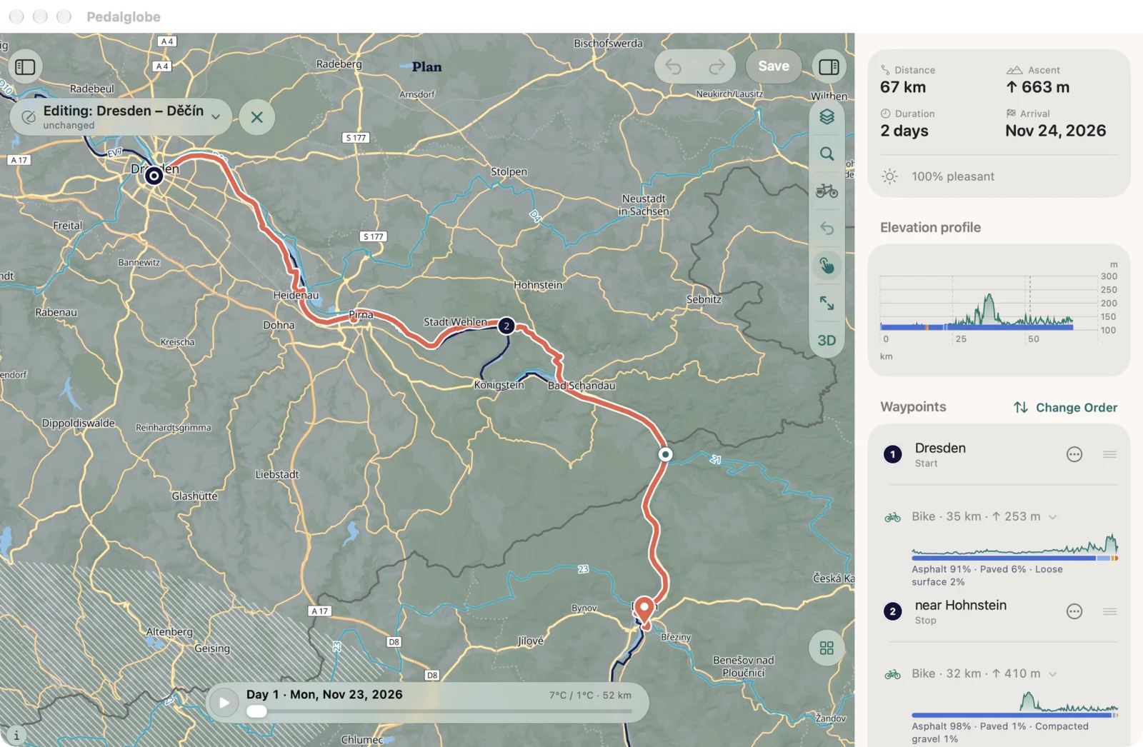
Pedalglobe as an iPad app on a MacBook Air: the route Dresden – Děčín in the planner, on the left the map with the route via Bad Schandau, on the right 67 km, 663 m of climbing, 2 days, the elevation profile and the waypoints with the surfaces of each section
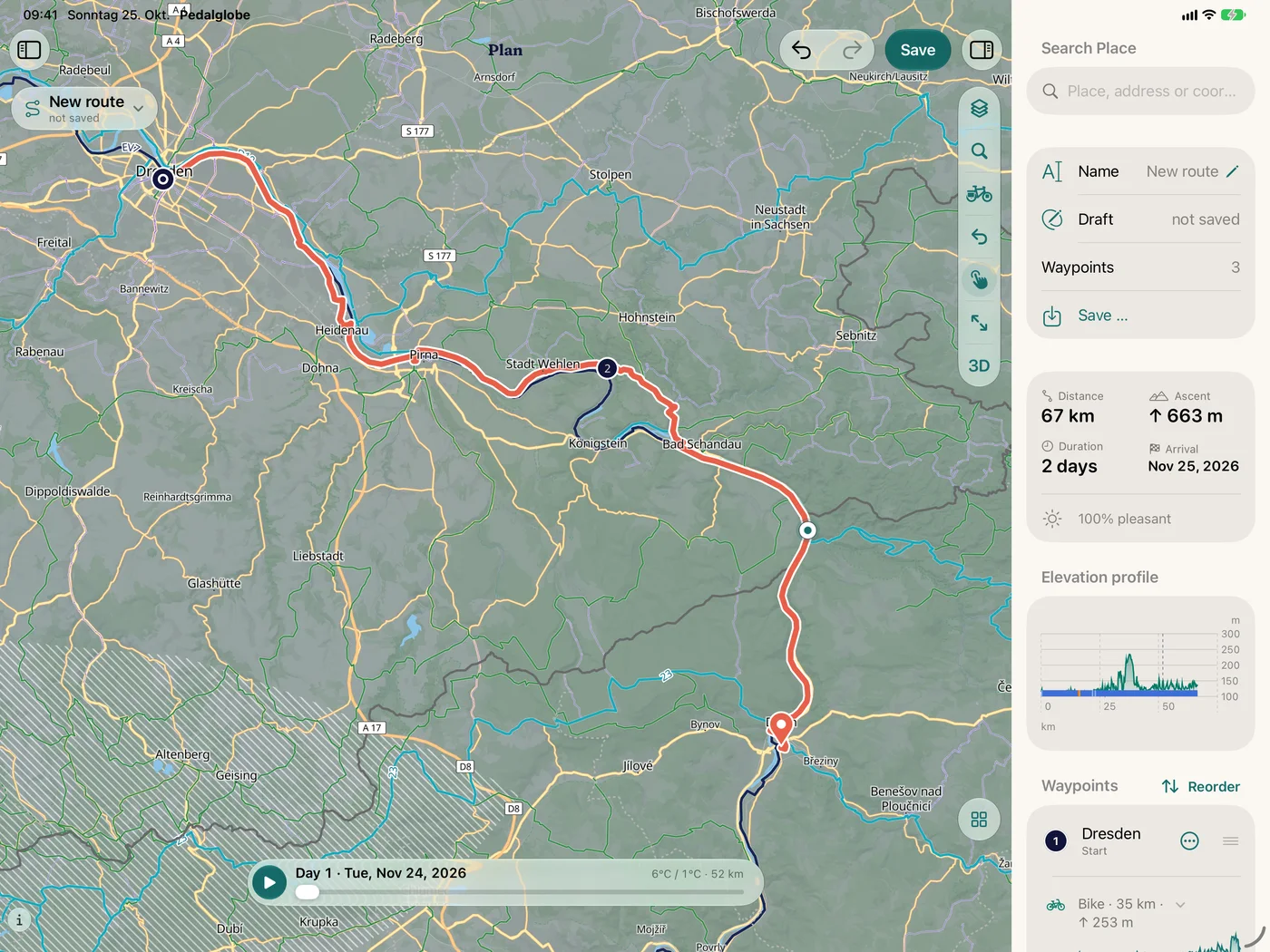
The same route on iPad: the map and next to it 67 km, 663 m of climbing, 2 days, the elevation profile and the waypoints
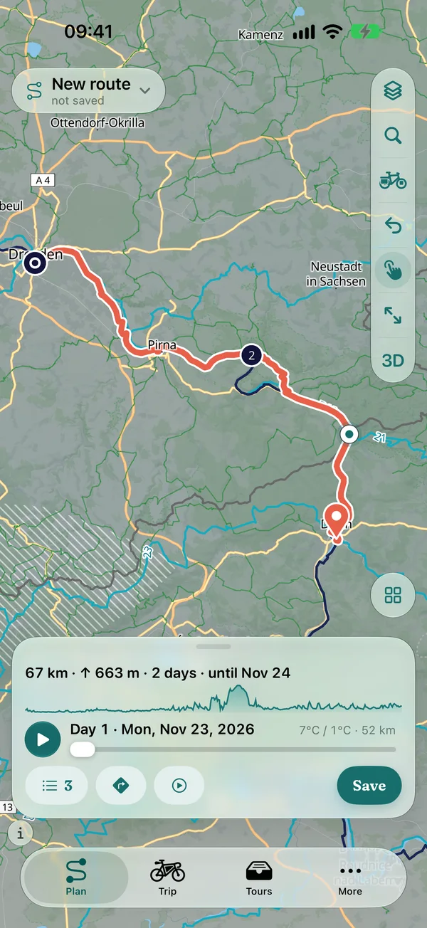
The same route on iPhone: planner with 67 km, 663 m of climbing and 2 days in the compact panel
The same route on Mac, iPad and iPhone

All features

iPad

Room for big plans

On the iPad, map and plan sit side by side: waypoints, elevation profile, days and countries on the right, the map at full height on the left. Planning, trips, navigation and the logbook use the whole width.
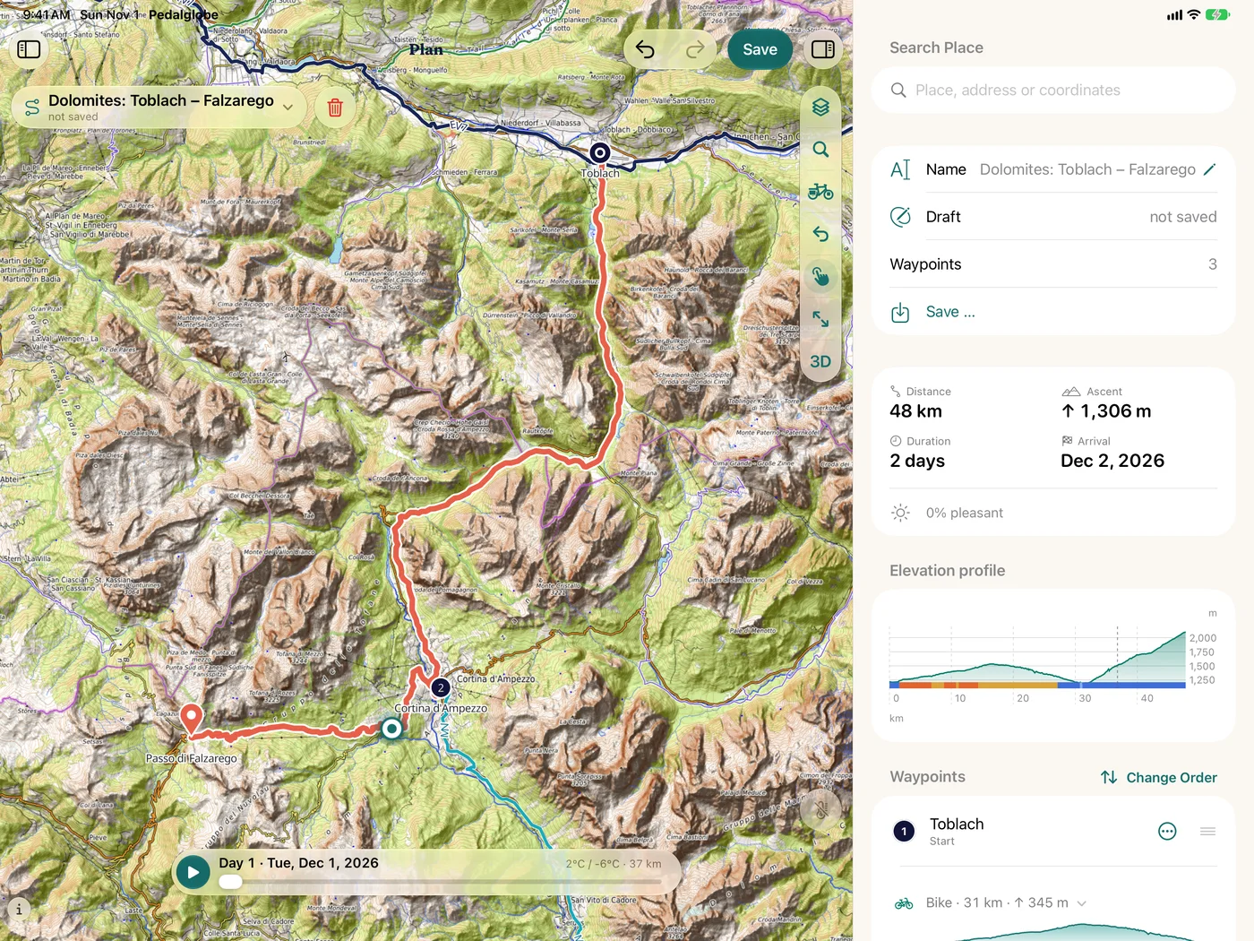
Planner on the iPad: draft “Dolomites: Toblach – Falzarego” on the topographic map with relief, on the right distance, climb, duration, elevation profile with surfaces and the waypoints
Over the Dolomites from Toblach to the Passo di Falzarego
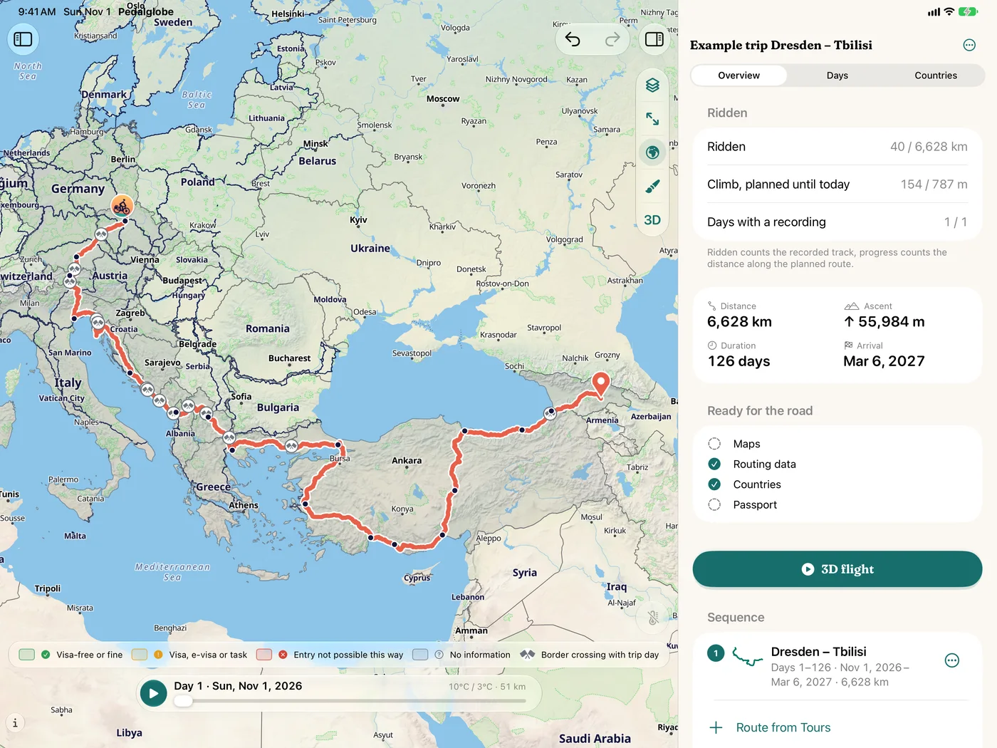
Trip on the iPad: the map with the example trip Dresden – Tbilisi and on the right the overview with distance, climb and 126 days
The whole trip at a glance

3D view

Landscapes in 3D

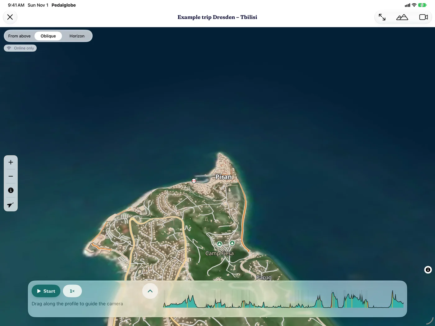
Open a route or trip in 3D and see the terrain it runs through. In large parts of the Alps, Germany and Czechia the open 3D map shows high-resolution aerial photos. The 3D view needs an internet connection.
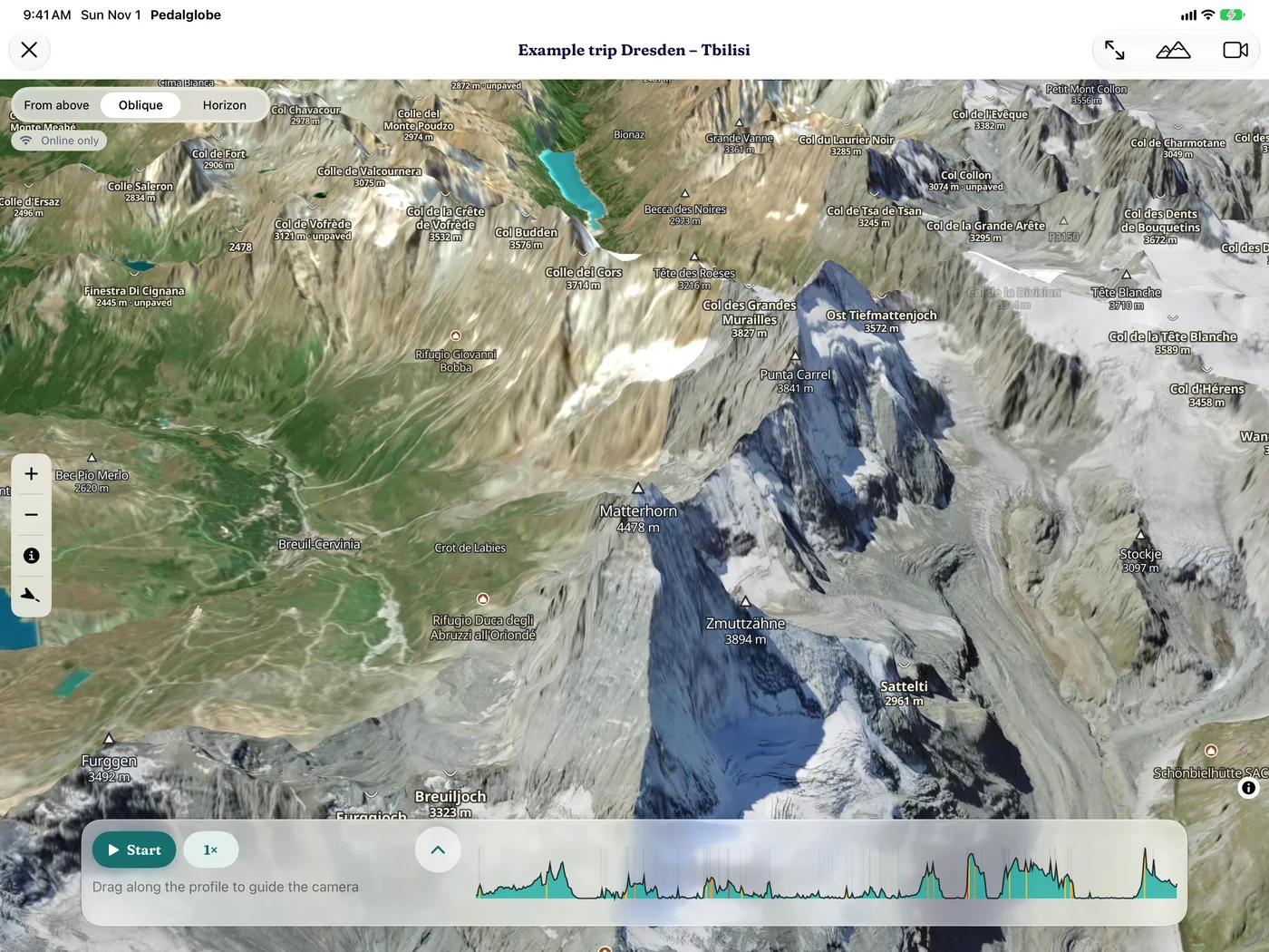
  • 3D view with aerial photos on the iPad: the Matterhorn with its glaciers and ridges
    Matterhorn
  • 3D view with aerial photos on the iPad: the old town of Piran on its headland on the Adriatic
    Piran
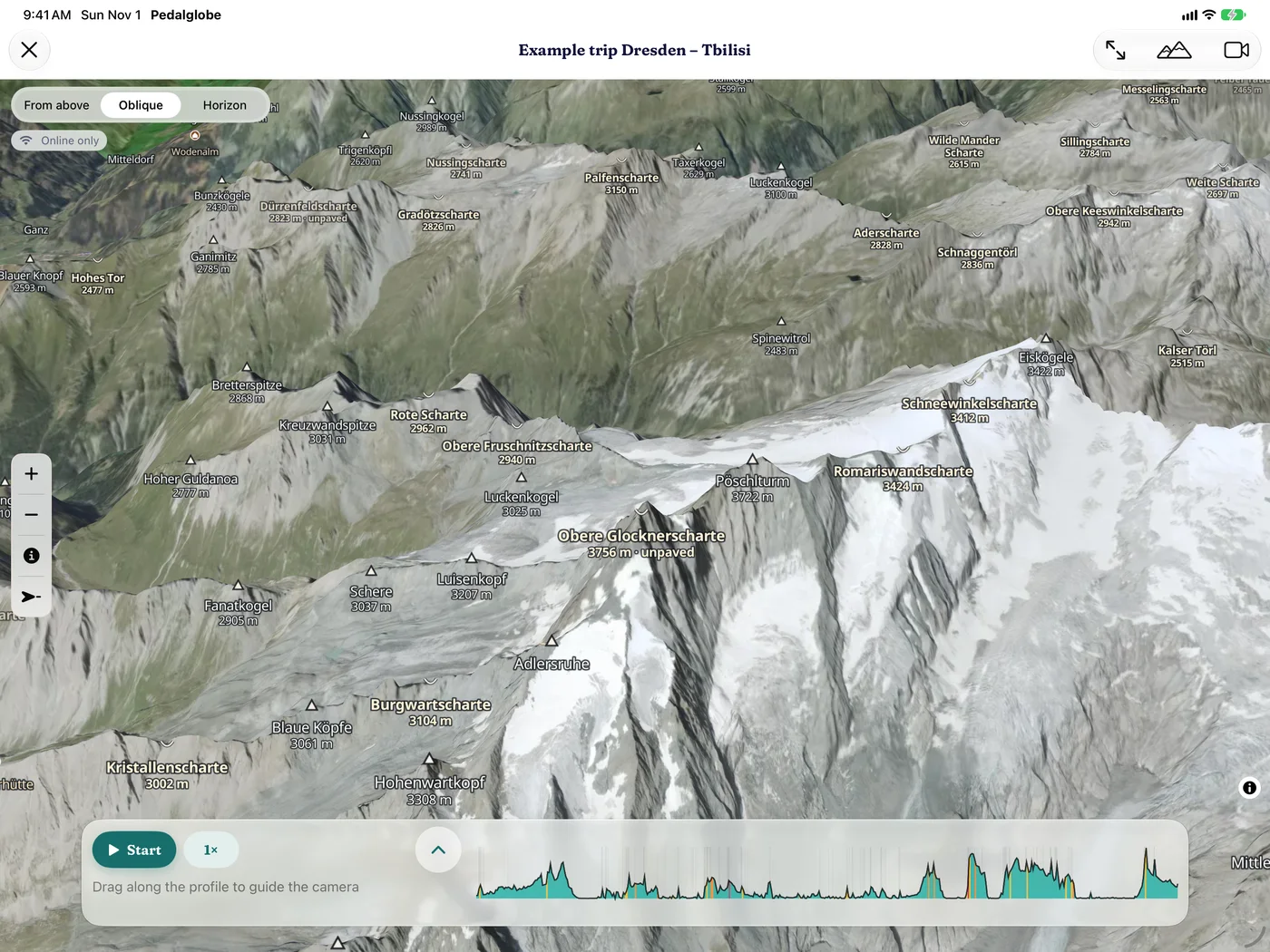
  • 3D view with aerial photos on the iPad: glaciers and notches on the Grossglockner
    Grossglockner
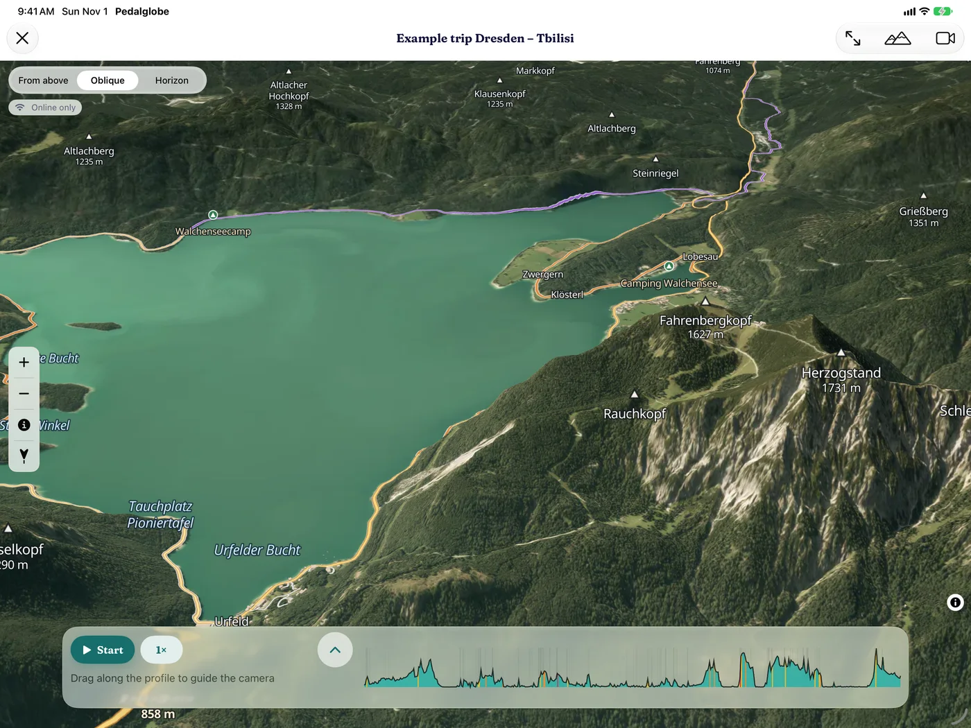
  • 3D view with aerial photos on the iPad: the Walchensee with the Herzogstand
    Walchensee
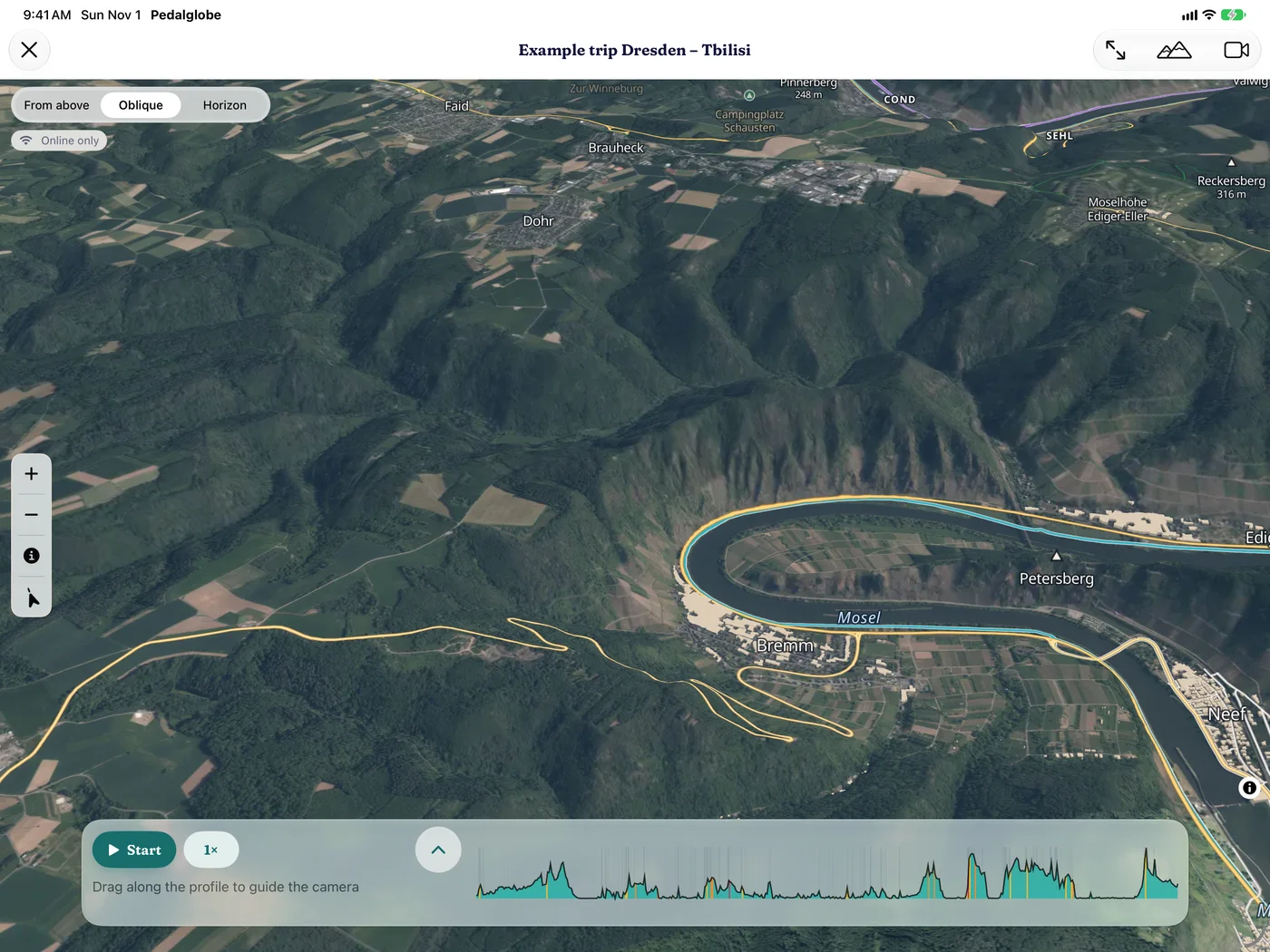
  • 3D view with aerial photos on the iPad: the Moselle loop at Bremm with its vineyards
    Moselle loop at Bremm
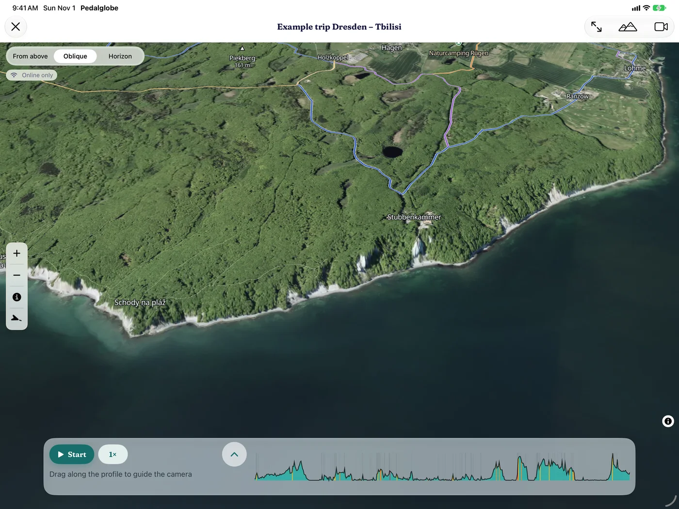
  • 3D view with aerial photos on the iPad: the chalk cliffs on the coast of Rügen
    Chalk cliffs on Rügen

World trip

Dresden – Tbilisi in 126 days.

The sample trip in the app: 14 countries from the Elbe valley across the Balkans and Turkey to the Caucasus. To try out, fly over and replan.

Panorama from Dresden to Tbilisi: church towers, mountains, mosques and the peaks of the Caucasus, in front a person on a touring bike
  • 6,628 kmdistance
  • 55,984 mclimbing
  • 126days
  • 14countries
Stamps of the 14 countries: Germany, Czechia, Austria, Italy, Slovenia, Croatia, Bosnia and Herzegovina, Montenegro, Albania, Kosovo, North Macedonia, Greece, Turkey, Georgia

Free and Pro

Free gives you every feature with one trip and any number of routes up to 1,500 km. Pedalglobe Pro is a one-time In-App Purchase, not a subscription.

Free

€0

No account, no ads

  • Every feature: climate, bike routing, offline maps, countries, map types, “Today”, iCloud
  • One trip (the example trip Dresden – Tbilisi does not count)
  • Any number of routes up to 1,500 km
  • All visa and entry information, always free

Pedalglobe Pro

€24.99one-time

Launch price · No subscription, with Family Sharing

  • Everything in the free version
  • Any number of trips, routes of any length
  • Roadbook as PDF and GPX per daily stage
  • 3D flight over any distance, video without watermark
  • Climbs at a glance: gradients in smoothly blended colours on map, profile, navigation and 3D, a warning before steep climbs
  • Your ride as a story: your stage in chapters with graphics

Side by side

FeatureFreePro
Trips1, plus the example tripany number
Length per route or tripup to 1,500 kmunlimited
Planning, climate, search, all map types, cycle network, relief, contour linesyesyes
Bike routing worldwide, six bike types, surfaces and climbsyesyes
Country packs and offline mapsyesyes
Country and visa information for the whole routeyesyes
Navigation with voice guidance, ridden trackyesyes
Travel mode “Today”, iCloud sync, backup fileyesyes
GPX of the whole route or trip, visa schedule as a calendaryesyes
Logbook, sharing through iCloud, image, PDF and tour fileyesyes
3D viewyesyes
3D flightup to 1,500 km and on the example tripany length
Flight as video720p, up to 60 s, with watermark1080p, full length, no watermark
GPX per daily stagenoyes
Roadbook as PDFnoyes
Gradients in smoothly blended colours on map, profile, navigation and 3D, a warning before steep climbsnoyes
Your ride as a story: your stage in chapters with graphicsnoyes

Existing routes and trips are never locked, even if they are longer. The price applies in Germany. In other countries, the price shown in the App Store applies.

  • No accountGet started without signing up.
  • Your data stays with youOn your device and, if you like, in your private iCloud.
  • No adsNo tracking, no analytics.
  • Eleven languagesGerman, English, French, Spanish, Italian, Dutch, Polish, Czech, Danish, Swedish, Norwegian.

Frequently asked questions

Does Pedalglobe work offline?

Yes. Download whole countries with routing and an offline map, or save the map along your trip or route. Offline you then have the map, cycle network, contour lines, routing, climate, place search, country information, routes and trips. A world overview map is always built into the app.

Satellite, relief and the 3D view load over the internet.

What happens to my data?

No account, no ads, no tracking, no analytics. Routes and trips stay on your device and, if you use sync, in your private iCloud. Pedalglobe uses your location only if you allow it, and only while you use the app. If you share a trip, only the people you invite see it.

The details are in the app privacy policy.

Can I share a trip with my family?

Yes, through iCloud: you invite people close to you to follow along or ride along, by message, mail or link. Everyone needs Pedalglobe with iCloud, there is no account with us. People following along see the route, progress, ridden tracks and your logbook, people riding along record their own rides. There is no live location, only your position while navigating if you like. For everyone else there is an image, the logbook as a PDF and the tour file.

Which devices does Pedalglobe run on? Is there a Mac version?

Pedalglobe runs on iPhone and iPad with iOS or iPadOS 26.1 or later, and as an iPad app on Macs with Apple silicon. Once bought, Pro applies on all your devices.

Which bike types are there?

Touring, gravel, road, bikepacking, mountain and e-bike. Every bike type has its own pace and preferences: the road bike stays on asphalt, the mountain bike takes any surface, gravel and bikepacking also ride on gravel.

Can I use GPX files from other apps?

Yes. When importing, you choose whether Pedalglobe keeps the track exactly (1:1), matches it to the ways the routing knows or aligns it to a cycle route nearby. You see both lines on the map to compare first. You can export as GPX, per daily stage with Pro.

Does Pedalglobe give turn-by-turn directions?

Yes. Pedalglobe guides you along your route with turn-by-turn directions and voice guidance in eleven languages, on a tilted map facing your direction of travel, day by day through your stages. After you arrive you carry on with the next day. “Overview” shows the remaining route, “Profile” elevation and surfaces, both without interrupting navigation. It keeps running while your iPhone is locked and records your ride. You can also take your routes to other apps and devices as GPX.

Does the app find addresses too?

Places, regions, mountains and rivers are found on your device, also offline. If you type an address with a house number, the app asks Apple Maps, only then and only with the search text and your approximate area. See “Address search via Apple” in the privacy policy.

Is this a weather forecast?

No. Pedalglobe shows long-term climate averages for 1995–2024 (cloud cover and wind 1981–2010). They tell you what to expect typically and help you choose when to travel. The weather on the day may differ.

Which passports do the entry rules cover?

Entry rules and the permitted length of stay cover EU, Swiss, Norwegian, UK, US and Canadian passports for more than 180 destinations worldwide, and part of the destinations for Australian and New Zealand passports. You can choose several passports. Country facts and links to official sources are shown for every passport and for more than 200 countries and areas.

Is Pedalglobe Pro a subscription?

No. Pro is a one-time In-App Purchase through your Apple Account. It applies on all your devices and, with Family Sharing, to your family group. After reinstalling, tap Restore Purchases under More.

Where do maps, climate and country data come from?

Map and cycle network are based on OpenStreetMap (© OpenStreetMap contributors, ODbL), the map comes via OpenFreeMap. Satellite imagery is made from Copernicus Sentinel-2 data, relief comes from Mapterhorn, elevation and contour lines from the Copernicus DEM, climate from CHELSA, CPC and CRU TS, places from GeoNames, country facts from Wikidata and Natural Earth. All sources and licences are listed under Data sources & licences.

More questions? Answers about iCloud, routing and purchases are under Help & support.
Social media